Chapter II
Explore the Sites
Four villages, one fortified corridor. Each kept a piece of the Order's stone — chapels, towers, commanderies and the bones of the walls that watched the frontier.
The Sites
- 01Castelo de VideWalls, the Order of Christ castle, and the Ermida de São SilvestreRead →
- 02NisaThe Templar administrative capital of the southern frontierRead →
- 03AlpalhãoThe lost commandery at the crossroads of two rival ordersRead →
- 04Crato & Flor da RosaMonastic seat of the Hospitaller Order in PortugalRead →
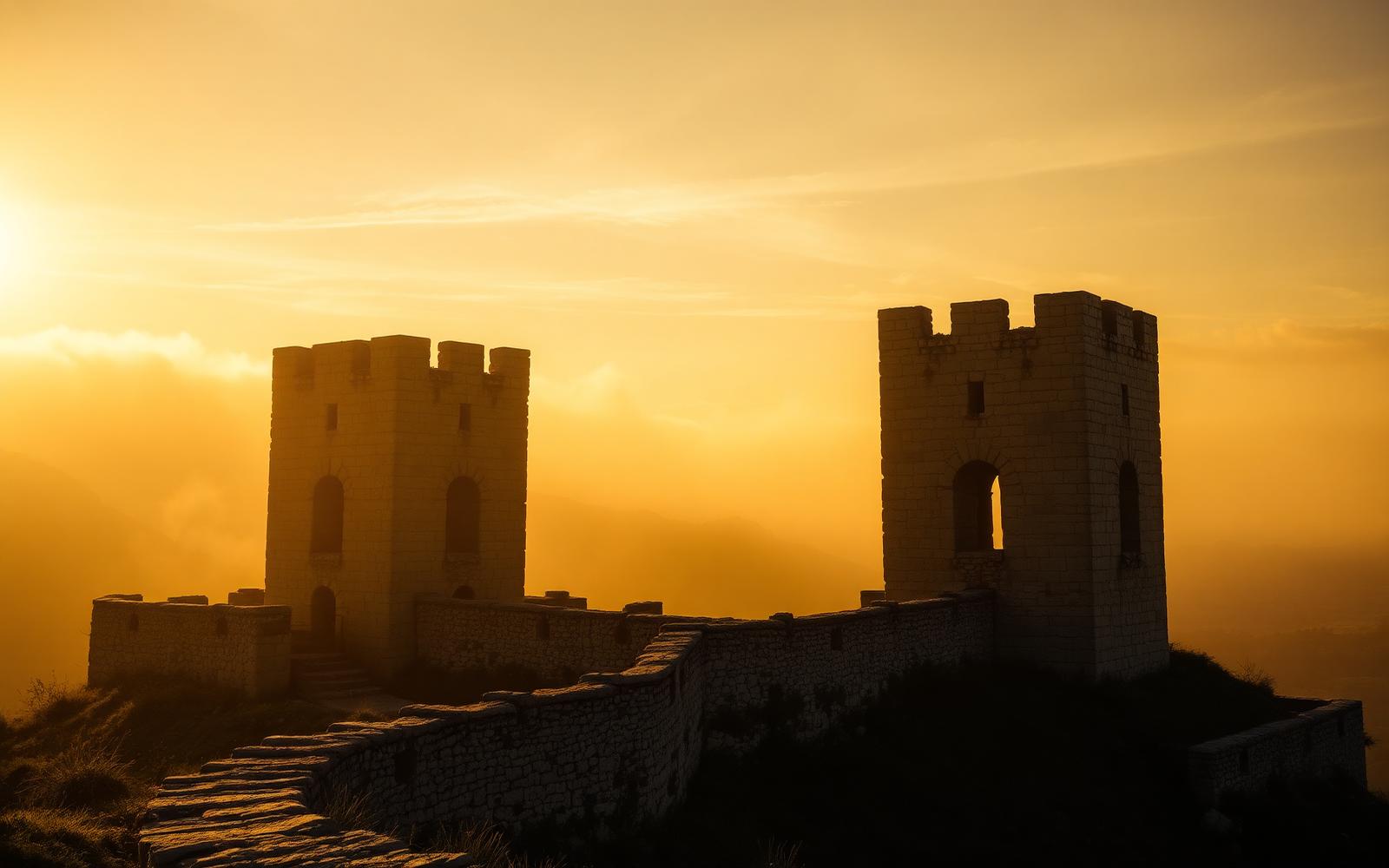
Castelo de Vide · District of Portalegre
Castelo de Vide
Where Three Histories Meet on a Hillside
Most visitors come to Castelo de Vide for the flowers. The town is famous for them — window boxes spilling geraniums over whitewashed walls, roses climbing the granite doorframes of the medieval quarter, the whole hillside in spring looking improbably lush for a region better known for summer heat and cork oaks. It has been called the Sintra of the Alentejo, a comparison that captures something of its prettiness while missing almost everything that makes it genuinely interesting.
Castelo de Vide is a town of layered histories so dense that even its walls are a palimpsest. The Templars' successors in the Order of Christ held the castle from 1372. The Jews built one of the best-preserved medieval synagogues in Portugal in a quarter that still carries their memory in its street names and its doorframes. The frontier wars came and went — the castle was rebuilt, damaged, rebuilt again, and partially destroyed by a gunpowder explosion in 1705.
The Castle and the Order of Christ
Conquered in the mid-twelfth century, the walling of the settlement of Vide was continued by King Dinis, with construction of the castle completed under his son, Afonso IV, in 1327. The castle that stands today is not a Templar building — it postdates the Order's suppression by fifteen years. But in 1372, Afonso IV donated the castle to the Order of Christ, in exchange for Castro Marim. The Order was made responsible for defending the territory, maintaining the frontier lines, and administering the region.
The Order of Christ, created in 1319 specifically to absorb the dissolved Templar institution, was in every meaningful sense the Templars under a different name. When its knights rode through the Porta da Vila and took possession of Castelo de Vide in 1372, they were following a route that Templar predecessors had established in the territory to the north more than a century earlier. They would administer this castle and territory for two centuries.
The Jewish Quarter — A Parallel History
Jewish life in Castelo de Vide dates back to at least the thirteenth century. The Jewish quarter developed at the base of the castle hill and, unlike in other Iberian towns, Jews here lived alongside Christians. By the fourteenth and fifteenth centuries, Castelo de Vide's Jewish population was thriving: merchants, artisans, physicians, and scholars contributing significantly to the town's prosperity.
The medieval synagogue, located at the intersection of Rua da Judiaria and Rua da Fonte, is now a museum. It is a small building — two rooms, with a carved stone Torah ark rediscovered during restoration work in 1972 — and its very modesty is part of its power. Walk the route from the main square up through the Rua de Santa Maria toward the castle, then down the north slope. On the doorframes of the oldest houses, small rectangular indentations mark where mezuzot were fixed — evidence of a faith practised in private, in spaces that look, from the outside, like any other medieval house.
The community's zenith came, paradoxically, from catastrophe elsewhere: the Jewish quarter reached its peak in the fifteenth century, after the expulsion of Jews from Spain in 1492. Many crossed the border a few kilometres to the east and made their way here — until 1496, when Manuel I issued his own edict of expulsion and the community dissolved.
The Ermida de São Silvestre — The Hidden Cross
Five kilometres northwest of Castelo de Vide, along a road that passes through cork oak and olive groves toward the village of Póvoa e Meadas, there is a small hermitage that almost no tourist guide mentions and that almost no visitor finds by accident.
The Ermida de São Silvestre is not impressive at first glance. It is a modest rural chapel, whitewashed, set in open countryside. But the reason to come here, for the visitor interested in the history of this territory, is not the chapel itself. It is what is carved into the ceiling.
In the keystone of the chapel vault, cut into the granite, is the cross of the Order of Christ — the direct successor to the Knights Templar in Portugal. It is not a large mark, not prominently lit or labelled. Most of the people who have attended the annual romaria for decades have never noticed it, or have not known what it means. It is simply there, in the stone, placed by hands that have been dust for centuries.
To find the hermitage, take the road northwest from Castelo de Vide toward Póvoa e Meadas. After approximately 4.5 kilometres, a track on the right leads across open ground to the chapel. Step inside, allow your eyes to adjust to the dimness, and look up. The cross is in the centre of the vault. You will know it when you see it.
Practical Information
The castle is open daily except Monday; access to the walls and towers is free. Allow forty-five minutes. The Jewish Quarter and Synagogue-Museum are best visited on foot from Praça de Dom Pedro V; allow ninety minutes. The Ermida de São Silvestre is approximately five kilometres from the town centre, accessible by car. GPS: 39.5391° N, 7.5245° W. Generally accessible during daylight hours; the chapel is typically unattended.
Nisa · District of Portalegre · 23 km from Castelo de Vide
Nisa
The Templar Administrative Capital of the Southern Frontier
Nisa does not announce itself. Driving in from Castelo de Vide on the N246, the road drops through cork oak forest and then climbs again, and the town appears on a ridge above the plain — a cluster of white houses, a church tower, the remnant of a wall. Nothing about it suggests that this was once the administrative capital of a Templar administrative territory stretching from the River Tagus to the Spanish border.
But that is precisely what Nisa was, for more than a century. And the evidence — quieter now, embedded in the street plan, the walls, the place names, and one chapel on a hill three kilometres to the north — is still there for those who know where to look.
Two Nisas
Most towns have one origin. Nisa has two. The Igreja de Nossa Senhora da Graça stands on the hill where the town originally began — a place known as Nisa-a-Velha, built on the site of a castle that once existed there. This was the first Nisa: a hilltop settlement, probably of pre-Roman origin, reconquered in 1166 with Templar support during the southward push of the Portuguese Reconquista.
Then, in 1281, the first Nisa was destroyed. The entire region was laid waste by the Infante D. Afonso, brother of King Dinis, in the context of a dynastic dispute over succession rights. The Templars, and then King Dinis, built a new town on a different ridge. The one that stands today.
The hill of Nisa-a-Velha, three kilometres north of the present town, is worth visiting for exactly what it is: the ghost of a place. The site includes an ancient hilltop cross, the ruins of the Igreja de Santiago, several fountains, hermitages, a pre-Roman hillfort, part of a Roman paved road, and a bridge of Roman and medieval construction over the Ribeira de Nisa. It is an archaeological palimpsest — layer upon layer of occupation, from the Iron Age to the moment the Infante's soldiers came and ended it.
The Templar Church — Built With the Castle
The Ermida de Nossa Senhora da Graça in the present town is probably one of the oldest religious buildings in Nisa — built by the Order of the Templars next to the castle. The spiritual and the military were never separate: a commandery without a chapel was an incomplete institution. The building as it stands today is a later structure — the medieval original was modified over the centuries, and the earthquake of 1755 forced significant reconstruction. But the foundation is Templar.
The Castle and the Walls
The castle the visitor sees today is the structure built by King Dinis in the late thirteenth century. Between 1290 and 1296, under Grand Master Lourenço Martins, a new Templar fortification was constructed on this site. The walls that followed, financed in 1343 by the Order of Christ using the revenues of the former Templar estates, enclosed the town that still largely defines Nisa's historic centre today.
The Porta de Montalvão — the gate whose name preserves a connection to the village of Montalvão, and through it to the history of the frontier — is the most evocative single point in Nisa for anyone who has followed the story of this territory. The views from the castle walls, across the plain toward Castelo de Vide and the Serra de São Mamede, make the strategic logic of the site immediately legible.
The Occitan Village Circuit
The full impact of the Templar administration of this territory only becomes clear when you drive the roads between Nisa and its surrounding villages. Arez is fifteen kilometres to the southeast. Tolosa is twelve kilometres to the west. Montalvão is twenty kilometres north, on the road toward the Tagus. The similarities between these place names and those of southern France — Nice, Toulouse, Arles, Montauban — have long attracted the attention of historians and local researchers, and remain one of the most intriguing open questions in the history of this frontier.
Drive the circuit on a late afternoon. The road takes less than an hour. The history it passes through covers several centuries and invites questions that are still being answered.
Practical Information
The castle ruins and walls are freely accessible at all times. Nisa-a-Velha is approximately three kilometres north on a minor road; allow thirty minutes. The Occitan village circuit (Arez, Tolosa, Montalvão) is best done by car; allow ninety minutes including stops. The Museu do Bordado e do Barro is open Tuesday to Sunday.
Nisa is twenty-three kilometres north of Castelo de Vide on the N246 — a direct road through cork oak country. Allow twenty-five minutes by car.
Alpalhão · Concelho de Nisa · 11 km from Nisa
Alpalhão
The Lost Commandery at the Edge of Two Kingdoms
There is almost nothing left. That is the first thing the visitor needs to know about Alpalhão, and it is also, paradoxically, what makes it worth coming to. Despite no longer having a standing fortified structure, what remains — a gateway, a clock tower, the village itself — can still be visited, and the absence of the castle is, in its own way, part of the story.
The castle that once stood here was real enough. It was documented, described, and measured. It controlled a strategic crossroads between two great military orders. It was garrisoned, rebuilt, and ultimately destroyed in a single morning in June 1704, when a Franco-Spanish army on its way to Portalegre passed through and did what invading armies do to fortifications they cannot use.
Origins: Roman, Templar, Royal
The ancient name — Fraxinum or Fraginum — suggests a settlement of Roman origin, believed to have stood approximately two kilometres north of the present village, on a hill known as Monte dos Sete. The Templars erected a castle here at some point between the mid-twelfth and mid-thirteenth centuries. The strategic rationale is clear: Alpalhão sat at the junction of the routes connecting Nisa to the north, Castelo de Vide to the west, and Crato and the Hospitaller territories to the south.
Then, in 1300, King Dinis built a new castle at Alpalhão, probably on the site of an earlier monastery — the Mosteiro de Alpalantri. The king who was simultaneously asserting royal authority over Templar territories across northern Alentejo built a castle here too, inserting the crown into a landscape that had been, until then, essentially a military order's administrative domain. The Templar dissolution of 1312 and the creation of the Order of Christ in 1319 transferred Alpalhão to the new institution.
The Castle in 1505 — A Voice from the Archive
Most medieval castles are known to us through their ruins. Alpalhão offers something rarer: a detailed written description, made by an official visitor in 1505, of exactly what the castle looked like when it was still standing and functioning.
The Tombo da Comenda de Alpalhão — the official survey of the Order of Christ's commandery assets, compiled in 1505 by Frei Francisco, the king's chaplain — describes the castle in precise terms: a tall, strong tower, entirely of lime and stone from foundation to top, well battlemented and of good width, with two floors equally well appointed, lined with chestnut wood in three panels and roofed with tile. On the lower floor, a seat window with its doors, still good, facing north. On the upper floor, four seat windows with doors, one in each corner, and a chimney with two hearths.
Read that description carefully and a building materialises. Not a ruin. Not an abstraction. A specific tower, with specific rooms, a fireplace that kept someone warm on winter nights in the Alentejo highlands. The chestnut panelling. The four corner windows. Duarte d'Armas, who sketched the castle around 1509 in his Livro das Fortalezas, shows a rectangular plan with the keep at the southwest corner and circular towers at the other angles — a building that was simultaneously a military installation and a comfortable residence for a senior officer of a wealthy religious institution.
The Defensive Line
Alpalhão was part of an integrated defensive line of the Order of Christ comprising three fortresses on the left bank of the Tagus — Nisa, Alpalhão, and Montalvão — which together organised a vast territory where the Order exercised seigneurial jurisdiction. To the south lay Hospitaller territory. Alpalhão was the hinge of this arrangement: too far north to be solidly Hospitaller, too far south to be comfortably within the Templar heartland around Nisa.
What to See Today
The old town hall still displays its insignia, marked Antiga — a former municipality, now absorbed into the concelho of Nisa. The Rua do Castelo leads through a narrow gateway toward the clock tower, the principal surviving element of the medieval complex. The staircase — freestanding, its destination long gone — stands as an inadvertent monument to the completeness of the 1704 destruction.
Stand at the gateway. The tower is to your right. The courtyard — seventeen and a half varas long, thirteen and a half wide, well laid and flat — was in front of you. The Templar knights who built the first structure here, sometime in the twelfth or thirteenth century, would have stood on this same ground. The dimensions haven't changed. The stones have gone.
Practical Information
Alpalhão is freely accessible at all times; no admission charge. The village has a café on the main square. Allow forty-five minutes for a thorough walk. Best visited in combination with Nisa (eleven kilometres north) and Castelo de Vide (fifteen kilometres west).
Crato & Flor da Rosa · District of Portalegre · 30 km from Castelo de Vide
Crato & Flor da Rosa
The Rival Kingdom — Where the Hospitallers Built Their Portuguese Headquarters
From the road, it looks like a fortress that forgot to become a church. The Mosteiro de Flor da Rosa rises from the Alentejo plain four kilometres north of Crato — a mass of grey granite, battlemented, turreted, its walls a metre thick, its windows narrow where they face the fields and unexpectedly tall where they face the interior courtyard. This is considered both one of the most important Gothic monuments in Portugal and the finest Portuguese example of a fortress church.
The Rival Order — How the Hospitallers Came to Crato
To understand Flor da Rosa, you need to understand the strategic landscape of northern Alentejo in the thirteenth century — which means understanding the relationship between the two great military orders that divided it between them. The Knights Templar held the north: the Açafa estate, the commanderies at Nisa and Alpalhão. The Knights Hospitaller, their sister organisation in the crusading tradition, had been accumulating territory across the central and southern Alentejo for a century.
In 1232, King Sancho II donated the town of Crato to the Hospitaller Order. In 1340, the headquarters of the Order of the Hospital of Saint John was transferred from Leça do Balio, near Porto, to Crato — placing them at almost exactly the midpoint between the Templar domain to the north and the Hospitaller territories spreading south. The Hospitallers began to build.
The Building
The Mosteiro de Santa Maria de Flor da Rosa was built from 1356 by the Grand Prior of Crato, Álvaro Gonçalves Pereira — classified as a National Monument in 1910, it is the most important monument of the Hospitaller Order in Portugal. The monastery comprised three distinct elements: a Gothic-style fortress church, a Gothic castle-like palace, and accommodation for the monks.
At the entrance to the church, the tomb of the founder — Álvaro Gonçalves Pereira — is still there, in marble. The man in this tomb was the Prior of Crato, the builder of this monastery, and the father of a child who would, at the age of twenty-five, lead Portuguese soldiers to victory against a Castilian force of more than thirty thousand and secure the independence of his country in an afternoon.
The Son — A Saint Made in the Shadow of These Walls
Nuno Álvares Pereira was born on 24 June 1360, the son of Álvaro Gonçalves Pereira, Hospitaller Knight of Saint John of Jerusalem and Prior of Crato. He grew up in the orbit of the Hospitaller institution his father led, in a landscape shaped by military orders and frontier warfare.
On 14 August 1385, at Aljubarrota, Nuno Álvares Pereira led a Portuguese force of approximately six thousand five hundred men to victory against a Castilian army of more than thirty thousand, ending the threat of Castilian annexation and securing Portuguese independence. The battle lasted less than an hour. He was beatified by Pope Benedict XV in 1918 and canonised by Pope Benedict XVI on 26 April 2009. He is the patron saint of the Portuguese army. The man who secured Portugal's existence as an independent nation grew up in the shadow of the building that stands, still, in the village of Flor da Rosa.
Crato Town
Four kilometres south of Flor da Rosa, the town of Crato is worth an hour of any visitor's time. The Igreja Matriz, the pelourinho in the main square, the remains of the medieval street plan: these are the bones of a town that was, for two centuries, the centre of one of the most powerful religious institutions in Portugal. The tecolameco — an almond sweet specific to the Crato region, still made according to traditional recipes — is worth seeking out in the local pastelarias.
Practical Information
The Mosteiro de Flor da Rosa is freely accessible as a monument; the church and exterior can be visited without charge. The monastery was converted into a Pousada de Portugal by architect João Luís Carrilho da Graça and opened in 1995; the Pousada occupies parts of the complex and requires a reservation. The medieval sculpture museum within is visitable; check current hours locally. Flor da Rosa is thirty kilometres south of Castelo de Vide on the N246 and IP2. Allow a full half-day for the monastery and the town of Crato.
When You Arrive
Stay at the centre of the corridor.
Castelo de Vide is within thirty minutes of Nisa and Alpalhão, and an easy half-day from Crato and Flor da Rosa. Our hotels sit within the medieval town the Order of Christ administered for two centuries.
Plan Your Visit